 |
|||||||||||||
 |
|||||||||||||
 |
|||||||||||||
|
|||||||||||||


Chapter 4
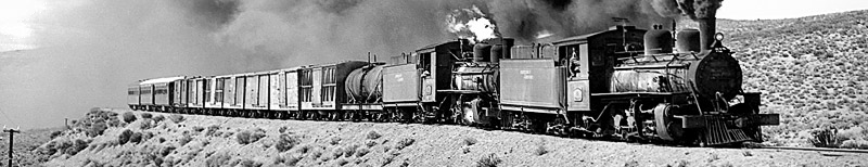
The FCE broad gauge network
Main pages
Bariloche line rolling stock •
Com. Rivadavia line extra photos •
Pto. Deseado line extra photos •
Pto. Deseado line extra photos 2 •
Appendices
2 Chronology of Patagonian railway proposals •
3 Bariloche line route itinerary •
4 Com. Rivadavia route itinerary •
5 Pto. Deseado route itinerary •
7 Com. Rivadavia line loco list •
8 Pto. Deseado line loco list •
15 FCP working timetable instructions 1960 •
16 Report on construction 1912 A •
17 Report on construction 1912 B •
21 President Alcorta address •
23 Purchase of wagons decree •
25 Early Patagonian proposals •
26 Progress to Bariloche 1926 •
28 Restructuring report 1953 •
Appendix 24
Transcontinental and international Railway from San Antonio Oeste in the Argentine to Valdivia in Chile
REPORT BY ENGINEER BAILEY WILLIS
Taken from the Boletin de Obras Públicas of the Argentine Republic, numbers 5 and 6 of the year 1912.
To His Excellency the Minister of Public Works, don Exequiel Ramos Mexía
By order of your Excellency, a Commission of Hydrological Studies was set up in the Directorate of Railways in January 1911, whose work has been directed in accordance with the instructions given by your Excellency to investigate the area of the San Antonio to Lago Nahuel Huapí railway and its extensions in the Cordillera. A year has passed since the creation of this Commission; I have the honour to make your Excellency aware of the work which has been done.
Referring to the reports previously submitted, it satisfies me to mention the study of the Valchetta reservoir, by which it is proposed to supply water to the first division of the railway, the adjacent plots of land, and the town of San Antonio; the project for the irrigation certain lands reserved from the auction of section II, by means of the waters in the Nahuel Niyeu and Yaminué streams; the topographic survey of some 10,000 square kilometres, showing in detail the relief of the lands, the courses of the water, etc. Also studied are various routes for railways in the high rough region of the Gran Anecon to the east of Lago Nahuel Huapí, and in accordance with the special instructions of your Excellency; the Cordillera has been explored, and the possibility of extending the railway within the Andes to Colonia 16 de Octubre in the south, to Junin de los Andes in the north, and as far as Valdivia, on the Pacific, in Chile.
These studies have confirmed unequivocally the wisdom which directed the construction of the San Antonio to Lago Nahuel Huapí railway and its extension to Chile. The national line is going to develop into a railway system that will promote livestock rearing in the flat lands [This phrase has been used instead of pampa to avoid any confusion with the Pampas, the vast grasslands to the north of Patagonia.] and the formation of a manufacturing population in the Cordillera, in conditions reciprocally favourable for mutual relations, and giving an an outlet onto two oceans by San Antonio or by Valdivia for the products of the Territory.
DESCRIPTION OF THE TRIBUTARY LANDS OF THE SAN ANTONIO TO VALDIVIA RAILWAY
Diverse regions.—The area which will be benefited in their development by the construction of the San Antonio to Lago Nahuel Huapí with its branches in the Cordillera, comprises 9,000 leagues in the Territory of Río Negro and in the adjacent parts of Neuquén and Chubut. This area finds itself formed of two very distinct regions: one the region of flat lands, the other the region of the Cordillera, differentiated by their climate, their vegetation, and especially by the distribution of water; the said regions will have different and complementary populations and uses and on the part of the
Government require different regulations for each one; because the region of the flat lands is suitable chiefly for livestock, agriculture being solely an auxiliary factor, while the region of the Cordillera is suitable for agriculture, for taking advantage of the forest and for the establishment of manufacturing populations.
THE REGION OF THE CORDILLERA
Its nature and potential richness.—The region of the Cordillera de los Andes which will be a tributary of the transcontinental railway from San Antonio to Valdivia by means of the proposed branches, extending from Junin de los Andes in the north in latitude 40º to the Palena river in latitude 43º 30 to the south of Colonia 16 de Octubre: and from the frontier with Chile in the west, to the sierras in the east which dominate the flat lands. In the north it touches the tributary zone of the Ferrocarril del Sud in its extension to the Neuquén river, and in the south reaches the limit of the goods traffic which could economically be sent to San Antonio or Valdivia.
Within these natural and artificial boundaries the land is characterized by a combination of very favourable features for the development of a dense population; the lands are rich; the climate is temperate and rainy; the rivers have big flows and strong drops; the lakes constitute precious reservoirs; the lands in the valleys give good harvests of grains, vegetables and fruits; and the forests on the side slopes constantly supply various types of wood.
The population, which will be occupied with intensive agriculture, taking advantage of the forests and the fabrication of wooden, leather and woollen articles, could reach up to two million people.
It is difficult to estimate the potential richness of this region. It may be compared with the prosperous areas of the north of Italy, Germany or United States; its future depends on the means of communication and the good application of laws apropriate to the development of the industries indicated.
Geografic description.—It is thirty years since it was thought that the Cordillera de los Andes was a chain of high peaks, which formed a continuous summit, from which the springs ran to both sides; but the exploration by Perito Moreno, and the studies of the Argentine-Chile boundary commissioners have established that the Cordillera is a wide area, 100 kilometres wide, more or less, characterised by extensive wide valleys, by big lakes, and by rivers with very tortuous courses be they towards the Atlantic or towards the Pacific, not related to any chain. To the south of Lago Nahuel Huapí the continental source of the waters is to be found in a bog, and in other places various tributaries of the Pacific are born in the flat lands to the east of the Cordillera, and traverse the heights through deep canyons.
In this labyrinth, the extensive basin of Lago Nahuel Huapí, penetrating from the flat country 100 kilometres to the north west of the Cordillera, and including the big lake with its various arms, as also the minor lakes of Espejo and Correntoso, is a significant feature. From the flat country it penetrates the heart of the Andes and the chains give an outlet to the plains; from the south a road, which leaves from Colonia 16 de Octubre, reaches the lake and in 250 kilometres passes by valleys between the chains, by the villages of Epuyen, Bolson and Los Repollos; and from the north leads from Junin de los Andes and San Martin by 150 kilometres to other valleys, still almost virgin, but which allow the longitudinal road of the Cordillera to pass. Thus the east point of Lago Nahuel Huapí, where the waves break on the low coast of the gravel plains, and from where the Limay river leaves with a rapid current, is the principal centre of the future population of the region of the Cordillera, being also the main terminus of the San Antonio railway
Thus Lago Nahuel Huapí divides the region of the Cordillera into to parts: one to the north, the other to the south: of the two, the one to the south is the more extensive, and that which can have the larger population. Towards the south, the pre-Cordillera is a sierra well marked with peaks which reach 2,000 metres, that is to say heights equal to those of the principal Cordillera, while between two fells, distant 60 kilometres one from another. In general the valleys drop down to 500 metres, and even 300 above sea level, and in the lower lake down to 145 metres; because of this, these valleys are well sheltered, and the rivers have strong falls. There are 27 lakes among the mountains in this region, with a total area of 526 square kilometres and they are linked in to four systems drain to the Pacific. From north to south they are: Manso river and its tributaries the Villegas and the Foyel; the Quemquemtren river, which discharges into Lago Puello and in its lower course is called the Puello river; the Fetaleufu river with the Cholila, Percey and Corintos; and the Palena or Carenleufú river. All these rivers have important flows which flowing through wide valleys, through extensive lakes or rocky narrows give rise to favourable conditions for damming the waters and for using them for the production of power. Some places are noted where considerable amounts of energy may be generated, such as:
Rio Villegas 500 000 horse power
" Fogel 100 000 " "
" Epuyen 650 000 " "
The sum of 1,250,000 horse power in these rivers represents only an insignificant part of the total available power in the region.
The existing populations between Lago Nahuel Huapí and Colonia 16 de Octubre amount to more than two thousand people, without counting nomadic ones, whose huts are to be found spread along the length of the road. In March 1912 the villages of relative importance which had been established were:
Approximate population
Bolson, village with school, shops, etc. 500
Hoyo de Epuyen, fenced farms, houses, etc. 300
Esguel, village with school, shops, etc. 1 000
Los Repollos, fenced estancia, with sheds, etc. 50
Total 2 150
Esquel, the village for Colonia 16 de Octubre, is the most important centre; the population of 1,000 people is made up mostly of Welsh and Germans; it has prosperous industries and commerce.
Bolson is for the most part made up of Chileans in Bolson itself or the new valley; it has a school, with two Argentine masters and 70 children; it has a flour mill, bakery, brewery and shops; the population is engaged in commerce and agriculture.
El Hoyo de Epuyen, Lago Epuyen, Cholila and Repollos are Chilean agricultural and pastoral villages, which have been established for ten years or more, and have the character of settled villages despite not having any title to the land.
The fact is that the area to the south of Lago Nahuel Huapí was settled by Chileans before the decision of the arbiter in respect of the frontier with Chile. The arbitration has not changed thesituation, because of the ease of access with Chile, and the lack of communication with Argentine populations.
From Lago Nahuel Huapí towards the north as far as Junin de los Andes, the Cordillera presents certain differences compared with the part south of the lake; the rivers run tothe Atlantic, with the notable exception of the discharge from Lago Lacar; their courses are in general from west to east and the corresponding valleys are transverse, separated by ranges which are in the same direction; the longitudinal valley of the Cordillera in this area is in a form distinct from that in the south. In San Martin it turns to the east and ends in the flat country; the range of the pre-Cordillera is lacking, the peaks of the transverse chains end in the high plains between the tributaries of the Limay. But the nature of the part to the north of the region, appears like that of the south in as far as population and industry, being an area of deep valleys, surrounded by high ranges, beautified by big lakes and suitable by virtue of its rich soils, crystalline waters and agreeable climate to sustain a dense population. A large part of this area still remains virgin, with the important populations on the plains, or eastern side slopes, with centres in San Martin and Junin de los Andes.
To the north of Junin the mountainous forested landscape extends for 100 kilometres between the frontier with Chile in the west, and the Aluminé river in the east, forming the northern point of the area of the cordillera favoured with abundant rain, because towards the north the amount of the annual precipitation greatly decreases, and the Andes present an inhospitable aspect.
The future of the region of the Cordillera.—The preceeding description deals with the region of the Cordillera between the parallels of latitude 38º 40' and 44º 25' which are different by virtue of their climate, their soils, their forests and their waters from all other parts of the Republic. It is bounded on the west by Chile and on the east by the flat lands and thus represents a special area which is recommended by its potential richness to the attentive study of statesman. It is still unknown and almost abandoned; we may compare it with areas of developed countries, and of like nature, taking into account the following data:
Area in Km2 |
Total population |
Per km2 |
Income $ m/n |
|
Cordillera region (north of 41º) |
14,500 |
– |
– |
– |
Argentine area (south of 41º) |
19,330 |
– |
– |
– |
Wurtemberg (Germany) |
19,512 |
2,049,079 |
105 |
55,000,000 |
Vermont (United States) |
24,772 |
343,641 |
15 |
4,000,000 |
Massachussetts (United States) |
20,374 |
2,408 |
118 |
27,000,000 |
without counting Stuttgart with 253 100 inhabitants and Boston with 595 380.
The state of Vermont in the United States is like the area of the Cordillera in Argentina for being a mountainous land, with an agricultural and pastoral population which shows the development which could be expected in a few years within the Cordillera by means of the construction of the railway, or say, an increase of 100% in the population and an income which would more than cover the interest on, and sinking fund for, the costs of the railway. Vermont produces forrage, grains and potatos; livestock is an important industry, the forests provide woods for various uses and businesses; the manufacturing establishments have a capital of about $ 150,000,000 national money; the railways reach a length of 1,740 kilometres, and include 200 kilometres of electric line. The climate of the state is harsher than that of the Cordillera, and its development has been limited by its location within the same national frontiers as the states of Massechussetts and New York, which compete in commerce and manufacture but with the advantages of location and climate. The area of the Andes indicated will not have a rival within the Argentine Republic.
The state of Massachusetts gives an example of more developed industries than Vermont, and a wealthier population; it is a community which by its high culture and its daring businesses has been made prosperous, notwithstanding its lack of natural resources; the soils are not good, a third part is more suitable for forests and pasture than for agriculture and there are no minerals of worth; the power of the rivers is the most important richness offered by nature to the population; but the geographic position of the state gives it access to raw materials so that the industrial establishments have reached an enormous development.
Wutemberg is a kingdom of Germany, whose physical conditions are more like those of the Cordillera, although its industries have an intensity which will not be reached in Argentine territory for many years; but its development is based on land, water and forests, in such proportion as considering it, it is possible to foresee the future of the Andean region. Of the area of Wurtemberg agriculture occupies 64% and the forests 31%. The state has a debt of £27,500.000 or $300,000,00 national money for the construction of national railways.
To justify the comparison of the region of the Cordillera with the states of Massechussetts and Wurtemberg it is necessary to consider the unique condition of the first, which distinguishes it from almost all the other areas of the Republic; the falls of water give it power which is generally lacking in the Argentine, and moreover will have the raw materials of woods, leathers and wools. Within the national boundaries rich populations are found in the agricultural and pastoral provinces, which constitute an immediate market for manufactured goods; and the rival manufactures of Chile, of Europe or the United States will have to face a customs barrier. With the construction of the San Antonio national railway, the region will have communication with a good port on the Atlantic, and by the extension to Valdivia in Chile, communication will be opened to the Pacific. Thus the Andean territory, currently an abandoned region, will be converted into a focus of industry and national richness.
THE RAILWAY SYSTEM OF PATAGONIA
Main line.—The Territory of Río Negro has two principal centres of population: the port of San Antonio on the Atlantic and the village of San Carlos de Bariloche on Lago Nahuel Huapi, distant 650 kilometres one from the other by the main line, the San Antonio to Lago Nahuel Huapi national railway. The immediate necessity of linking the two places is urgent for the administration of the Territory, since despite the railway's having been built as far as Km. 340 from San Antonio, it requires eight days on horse back or in a coach to reach Bariloche, thus this village is almost isolated from the representatives of the Executive Power in Viedma. A little farther away, in the region of the Cordillera the isolation is complete. Thus the construction of the line to Lago Nahuel Huapi is a duty of the Government, among other reasons, to facilitate the sale or lease of fiscal lands, to populate the Territory and to establish the commerce of products and imported goods which have to pass through San Antonio. These reasons demonstrate the convenience of the construction of the San Antonio to Lago Nahuel Huapi national railway, considering it as only an inter-territorial line, and as a trunk of a system essential in the future for the Argentine power and richness.
Branches in the flat country.—San Antonio currently has no communication with Buenos Aires other than by sea, but the construction of a railway which will link to Bahía Blanca is inevitable. It will be the root of a Patagonian railway system which will penetrate the rich soil of Buenos Aires; later the system will extend another root towards the south, to Puerto Madryn, and even further afield as a section of the Atlantic line.
From San Antonio towards the west, following the trunk of the system in the interior depresions in the flat lands, whose waters do not reach the sea, there is no need to form branch lines until the route passes the sources of the Limay and Aluminé (or Colluncurá) rivers, which come from the north. By the Limay and the Aluminé the branch would reach Junin de los Andes after some 220 kilometres. The distance from Junin to San Antonio by this line would be some 750 kilometres, more or less.
To communicate with the lands around the sources of the Chubut river the main line could take advantage of a pass between the Cumallo stream and the Las Bayas stream; following the latter downwards, the line would head towards the west upstream to pass Lago Nahuel Huapi; while a branch would diverge towards the south downstream over the table land to the east of Cañadón Río Chico, which is not passable by a railway; making use of the route already surveyed by the railway directorate; the branch would continue by Fofocahuel to Colonia 16 de Octubre. San Antonio would be 850 kilometres away.
Thus by the Cumallo towards the north and by Las Bayas towards the south, the trunk of the railway system may extend branch in the flat country to the east of the pre-Cordillera as far as Junin in the north and as far as Colonia 16 de Octubre in the south. Other branches could be made in the Cordillera.
Branches of the Cordillera.— The principal line will reach the eastern point of Lago Nahuel Huapi, and will follow by the north shore and by various lakes and passes to the summit of the Andes and will cross into Chile to continue to Valdivia by Paso Cajón Negro*. The length of the route from the Río Limay, where it drains from Lago Nahuel Huapi to the summit, will be some 135 kilometres. Two branches will leave this part of the main line in the Cordillera: one from the east point of Lago Nahuel Huapi to, by which it would follow the shore heading southwards and pass by Lago Gutiérrez at the valley between the pre-Cordillera and the Cordillera and will reach Colonia 16 de Octubre with a length of 250 kilometres more or less; the other in the north leaving from Lago Villarino, and passing by Valle Hermoso and San Martin, to Junin de los Andes, 85 kilometres. These branches have been described in the aforementioned Boletin.
Summary.—Thus the railway system, which concentrates the traffic of the flat country, and that of the region of the Cordillera to the south of the Río Negro on the port of San Antonio, will be found formed by the trunk, which extends from San Antonio to Lago Nahuel Huapi, two branches which join together in Junin de los Andes and two which will reach Colonia 16 de Octubre, the extension of the principal line will give these railways, and the extensive region which they traverse, an outlet to Valdivia in Chile.
The richness of the region of the Cordillera and the urgent need to take possession of that Argentine territory, demand that the trunk and the branches within the Cordillera are made as quickly as possible.
THE TRAFFIC OF THE SAN ANTONIO TO VALDIVIA RAILWAY
The San Antonio to Valdivia railway will have international traffic and transcontinental traffic; and for each type of traffic would have movement from west to east as well as east to west.
Provincial traffic.— The provincial traffic will consist in the transport of the products of the territory, that is to say, wool, leather, lucerne and wood, to which will be added eventually the manufactured goods produced in the region of the Cordillera. Presently wool and leather is exported to England and Germany, and will continue to be exported, until manufacturing industry is established in the Cordillera; its centre of transportation will be near Huanú Luan, some 400 kilometres from San Antonio and 250 kilometres from Lago Nahuel Huapi; that is to say, if all the traffic in wool and leather, which will be distributed along the line, could be concentrated in a single point equivalent to the centre of gravity of all the loads, that point would be it; for this the transport of wool and leather will have an average journey of 100 kilometres to San Antonio or 250 kilometres to Lago Nahuel Huapi. In a few years the movement of these raw materials towards the west for manufacture must become important. The transport of wood will always be from the region of the Cordillera towards the east, to be used in the flat country, or for export from the territory; this type of load will not be of great importance until the branch lines of the railway penetrate the forest, but will increase greatly with the reduction of the importation of wood from the United States of America, where there is an imminent shortage which results from the destruction of its immense forest riches. Lucerne will be grown in the valleys, on the flat lands and in the pre-Cordillera, where the lands and waters are suitable; the appropriate areas will be limited in proportion to the need for this type of forage, and the transport movement will be generated within the Territory from the areas where lucerne may be cultivated, to those which do not produce enough for the local livestock. More lucerne will probably be produced than wheat or other grain harvest, with which the territory of Río Negro will never be able to compete with the province of Buenos Aires.
To this regional transport of raw materials will be added that of manufactured goods of wood, wood and leather, which will have to be made in the region of the Cordillera, or centres in the western part of the flat country, where it may take advantage of the power of the rivers converting it into electricity and distributing it. The manufactured goods will be sold in the territories and provinces to south and north in the whole Republic, distributing it via San Antonio and the sea or via Bahía Blanca, the movement will be from west to east towards both centres of commerce.
International traffic.—International traffic on the San Antonio to Valdivia railway will consist in the movement of raw materials from their point of origin in the flat country to the centres of fabrication in Chile, as will be inevitable, as the production of raw materials in the Argentine will be such that will not allow them to be manufactured in this Republic for which Chile could stock up with them to supply their factories; in 1910 Argentina exported livestock products to Chile worth $ 12,000,000 national money (96% of the total imported by Chile) and the export must increase proportionally the development of the respective industries in the two countries. Livestock in the Territory of Río Negro will find in Chile an important market for its products and having ports on both oceans will give it a place of great advantage.
Transcontinental traffic.—Transcontinental traffic, that is to say, between one port and another by the San Antonio to Valdivia line, will be limited to the transport of goods originating in the countries of the Pacific, and destined for markets in the Atlantic, south of Río de Janeiro. The railway line will have to compete with sea traffic by way of Cape Horn ,or by the Straights of Magellan, and will be limited to articles whose worth would justify the transshipment. Japan for example is going to establish a shipping line which will pass through Panama to the north east coast of South America, and which will reach perhaps to Rio de Janeiro; but the corresponding commerce bound for Buenos Aires should go via Valdivia and the transcontinental railway. Being the shortest possible line passing through the Cordillera by a low pass and with gentle gradients this railway can compete with advantage over other projected transcontinental routes.
CONCLUSION
The conclusion of the work of the Commission on Hydrological Studies is the continuation of the work. In accordance with the orders of your Excellency, the engineers continue the survey of the land, and the economic and scientific studies of the water along the San Antonio to Lago Nahuel Huapi railway, hoping to conclude the task in the area of the lake in the second year.
I salute you with my most high consideration and remain your servant always at your orders.
BAYLEY WILLIS
Head of the Commission of Hydrological Studies
[1542B]
27-1-2018