 |
 |
 |
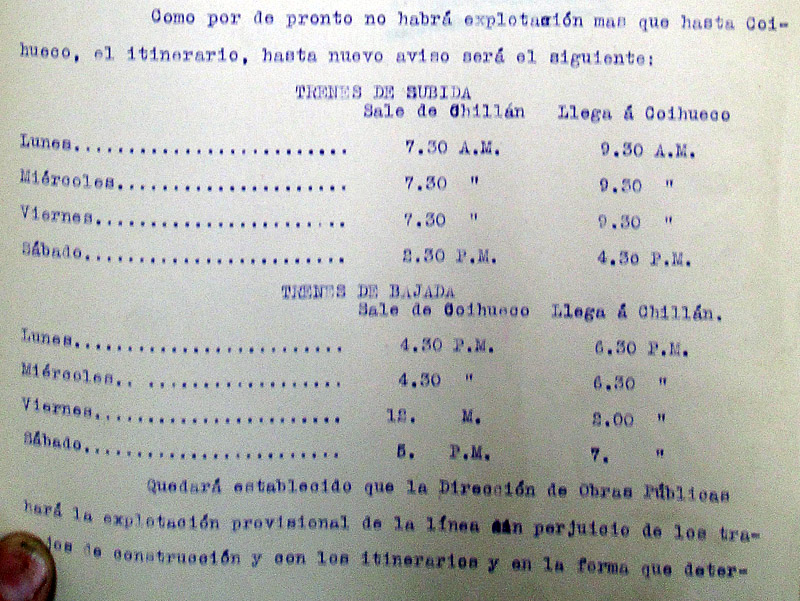
|||||||||||||||||
 |
|||||||||||||||||||
|
|||||||||||||||||||
The line from Chillán to Coihueco, Pinto and El Recinto, on the way to Las Termas There were a number of proposed 60cm gauge lines investigated in this area, including routes from Bulnes and San Ignacio that would have combined to create quite a large system, but in the end the decision was to construct a ‘mainline’ from Chillán via Coihueco and Pinto towards the ‘Termas de Chillán’ hot springs up in the hills beyond Recinto, and one minor branch from Coihueco north-east to Niblinto.
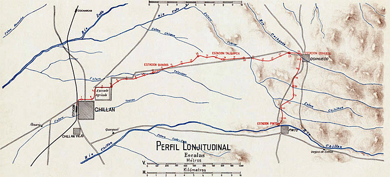
The landscape The route The map below shows the first half of the route, as far as Pinto. A larger version, complete with title and gradient profile, is available on an appendix page.
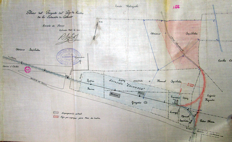
Turning almost immediately east, the line ran along the Avenida Brasil, with a paradero where Calle Francia comes in from the north. After around 2 km, the track turned north along the present day Avenida Argentina, with another paradero named Santa Elvia after a couple of hundred metres, where the current barracks of the Regimiento de Chillán has its entrance. Whilst this section is all on relatively flat land and parallels the main road to Coihueco, the alignment did not adhere closely to the road, diverging from it repeatedly for most of the 23 km. Whilst Avenida Argentina is now the main way out of town towards Coihueco, this was not the case one hundred years ago, and the railway skirted the northern boundary of the Escuela de Agricultura's grounds (now part of the Universidad de Concepción) in order to cross the then main road and cut a few corners rather than following the zig-zag path that the highway then took. At around Km. 10 of the railway route there was to have been constructed an Estación Quindos where the track crossed the main road for a second time at a very acute angle to end up on its north side for the next 10 km or so. The station seems to have been built, but was actually designated General Lagos. Continuing eastward, the railway spends the next ten kilometres on the north side of the road. Towards the end of that section comes the village of Talquipén with a station that still survives after years of use as the local school. A couple of kilometres further and the line crosses back to the south of the road for four kilometres before reaching Coihueco at Km. 26.??? This was the end of the almost straight course eastward, for just beyond the station the route to Pinto and El Recinto turned sharply south whilst the branch to Niblinto made a similarly acute turn to the north. The plan below shows Coihueco station and the proposed short branch to a gravel pit just to the north. This was required to provide ballast for the route south to Pinto, hence the third side of the triangle giving direct access for trains to and from the pit. The first curve was later used as the start of the Niblinto branch.
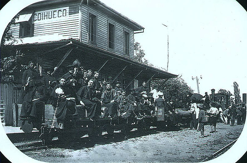
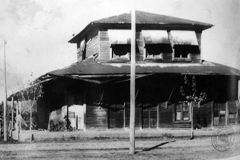
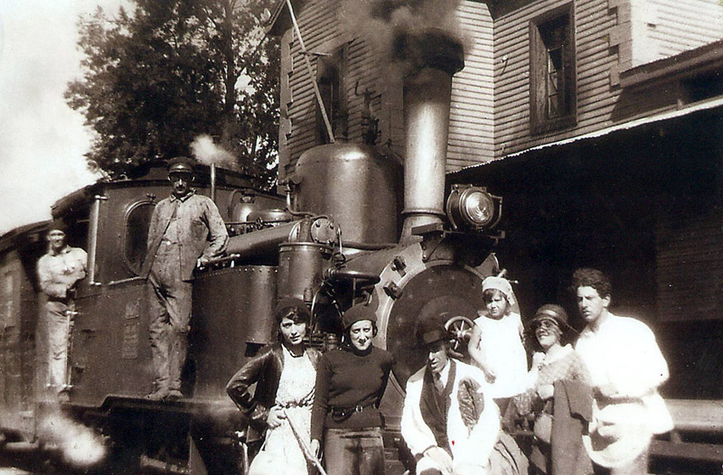
The main building at Coihueco was of the same style and shape as those at other intermediate stations such as Pinto. This was expressly described as a new and cheaper design of ticket office and administrative building for this line, but seems to have then been adopted on other lines, eg. at Lumaco and Saboya. This one no longer exists but it seems that the 'casa de camineros' a few metres further east does survive, as shown further down this page. This photo shows a small teutonic-looking tank loco at the far end of a rake of wagons, possibly a tipo c 0-4-0T, or one of the DOP's Hanomag 0-4-0Ts.
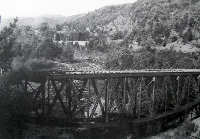
Nine kilometres further south is the end of the first section constructed, on the north side of the Río Chillán opposite the settlement of Pinto. There was one 'paradero' halt on this stretch, at Roblería, about 5 km south of Coihueco, and named after the oak trees of that locality. Pinto itself is raised above the river on the southern bank, and though it might have been more convenient for the residents if the station could have been within the 'pueblo', the arguments for continuing eastward along the north bank meant that it was constructed some way from the centre of the settlement. The precise route east from Pinto has not yet been fully identified. However, there were two more intermediate stations and a halt on the way to El Recinto. The stations were at Tanilvoro and Esperanza. Roughly two-thirds of the way from Pinto on to El Recinto the line crosses to the south of the Río Chillán by a single span deck (underslung) truss bridge.
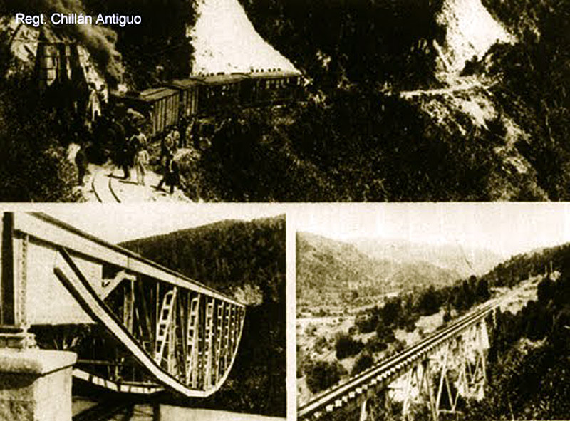
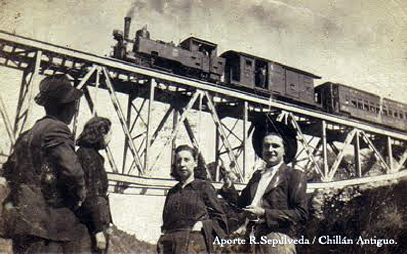
A group of images, showing the Río Chillán bridge and a multi-span steel bridge at an unknown location on the line.
Construction It is worth noting that around 1907 the decrees granting permission for the construction from Chillán to Coihueco also included references to branches to Bustamante (near Niblinto) and the Isla de Cato, whose location has not yet been discovered. The contract was terminated prematurely at the beginning of 1910, owing to various difficulties encountered, and the construction work was completed by the DOP's own workforce. The station building at Pinto is clearly of the style pioneered at Coihueco and adopted for a number of stations on various 60cm gauge branches. This view shows the building after the lifting of the tracks.
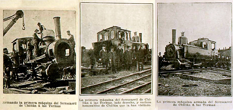
The task of construction of the section onward from Pinto to the east was awarded to don Victor Leon Núñez by decree 2608 of 14th September 1911. It seems that the sub-branch to Niblinto was surveyed and constructed between 1914 and 1916, using plans developed by Ing. Pedro Soto. In 1919 it was reported that the army had completed the construction of 5.5km east of Recinto towards Las Trancas, out of a total of 23km. Another 1km had been started. These sections were never opened to traffic. Locomotives and rolling stock By the end of 1909 or in early 1910 tipo a 0-6-2Ts, Jung nos. 1350 and 1351 (named locally as 'Presidente Pedro Montt' and 'Vicente Méndez Urrejola'), arrived, followed by 2034. These were erected at Chillán, and seem to have been numbered 1, 2 and 3. In April 1913 they were joined by tipo b 0-6-0Ts 19 'Alejandro Bertrand' (Jung 1854) and 20 'Matilda' (Jung 1855) which were locally renumbered 4 and 5 to follow on from the tipo a engines. An additional tipo b had arrived by 1914, 18 'Víctor Klein' (Jung 1853). Somewhat later, a small 7.5T loco at Chillán on construction work in 1917 was to be handed over to the Señor Intendente del Ñuble as part of a financial settlement. The first locos for the new narrow gauge branches were erected at each of the construction sites rather than at a main works. Thus the two tipo a 0-6-2Ts ordered for Chillán to Las Termas in 1909 were erected at Chillán.
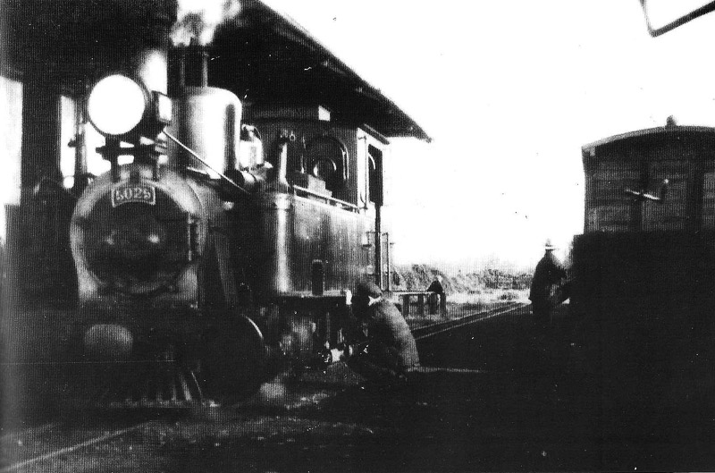
As usual, knowledge of which specific locos operated on each line during the EFE years is limited to evidence from photographs. This limits us to saying the tipo a 0-6-2Ts nos. 5025 and 5060 ran from Chillán for periods, but gives us no clear evidence as to when they were here. Tipo a loco number 5025 at Recinto.
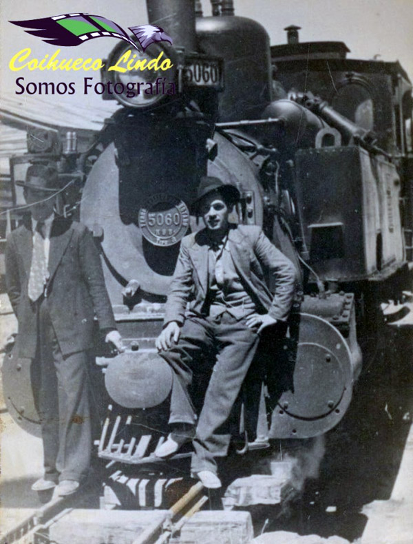
5060, one of the 1929-built tipo a engines.
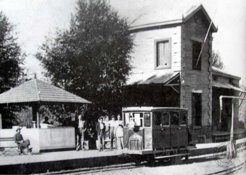
The EFE purchased three Fairbanks-Morse auto-carriles very early on for the 60cm gauge lines, round 1914. This may have been one of them, seen here at Recinto.
Operations
A tipo a loco crosses the Río Chillán bridge.
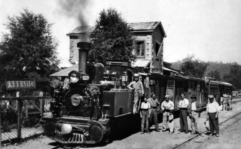
The later tipo a locos were slightly different from the earlier ones. Nos. 5058, 5059 and 5060, all of which supposedly ran on this line, had a slightly longer overall wheelbase and had flat fronts to the tanks, as here, rather than rounded fronts as on the original locos. This pictures shows 5060 at Recinto, having brought in a four vehicle mixed train.
And another photo at Recinto station, this time with the tipo a loco facing the other way. The location is confirmed by the flagpole mounted on the front of the station building, a feature not found elsewhere. Note also the difference between the rounded tank fronts of the earlier Jung tipo a locos (below) and the flat fronts of the later engines (above).
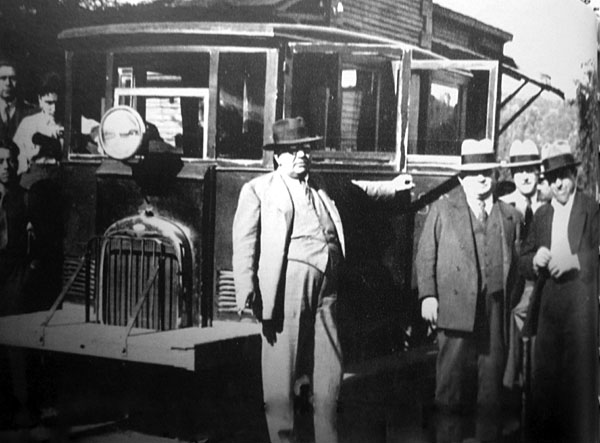
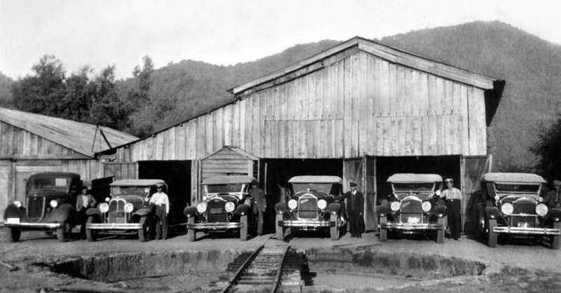
The railway never got any further east towards Las Termas, so an onward link was provided by taxis. It rather looks as though the loco shed has become a garage in this view, though the cars themselves suggest that this might have been whilst the railway was still operating. Possibly trains always returned immediately to Chillán and thus the loco shed had become redundant.
The line was twice used by Presidents of the Republic on their way to stay at the Termas de Chillán, Presidente don Carlos Ibáñez del Campo in 1930, and Presidente don Arturo Alessandri Palma in 1934. Extension from Niblinto to San Fabián de Alico was suggested in 1935. 1939 saw a strong earthquake in this part of Chile. The line was blocked for just five days, after which the route became an important channel for aid to the area around Recinto. This locality had been particularly hard hit, with the local sulphur and potash businesses that used the railway totally destroyed. 1945 A violent collision between a train and a bus occurred outside the Escuela Agrícola on the outskirts of Chillán. A number of passengers were injured. The following year a serious derailment occurred at Esperanza station, but fortunately there were again injuries but no deaths. In 1949 another collision with a bus occurred, this time at Km. 19 near Coihueco. Closure Se ven en un apéndice fotos adicionales, incluyendo unas tomadas en 2016 ilustrando las reliquias de hoy. Further sources of information 23-2-2018 |
|||||||||||||||||||
Chapter 6
The Chiloe Island 60cm gauge railway