 |
 |
 |
|||||||||||||||||
 |
|||||||||||||||||||
|
|||||||||||||||||||
A Chilote line Chiloé Island lies in Chile just south of Puerto Montt, where starts the long line of 'canales', fjords and islands stretching southward for several hundred miles. The island is roughly rectangular, about 110 miles north to south and 15 to 40 miles across. In the past Chiloé had a fairly wild reputation and its inhabitants could be found all over Patagonia doing any sort of rough or seasonal work. These days tourism seems to be growing, not least to the unspoilt forests and wilderness areas, and to the traditional wood-built villages. Map of Chiloé Island
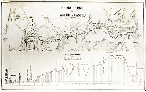
Proposals Surveys Ancud Museum displays a preliminary survey map of the route. The version below, from the Gilverto Provoste collection (3), is from somewhat later, though clearly the precise route was still up for debate. The final path chosen was different in a number of respects, as explained below. The longitudinal profile is also of interest for it clearly shows how the dissected nature of the Chiloe uplands forced the line to make frequent and steep changes of height. Some readers may wish to see a larger version of this map, so one has been provided on an appendix page.
The national context At the beginning of the 20th century Chile had a growing 'Central' network gradually extending south towards Puerto Montt. This would later be termed the 'Red Sur' or southern network. In the north was the metre gauge network, later to become Red Norte, and a number of independent railways supporting the various mineral producers. From around 1906 onwards the DOP were investigating the possibility of a number of new 60cm gauge railways, to extend the government network into areas where wider gauges could not reach or could not be justified. Around 1909 work had started on the construction of five routes: They were also actively commissioning studies into the following further 60cm possibilities: Thus from around 1910 onward, the Dirección de Obras Publicas were gradually bringing new 60cm gauge routes into operation, with a view to eventually handing them over to the FCE. The only one of these narrow gauge lines which did not follow the conventional pattern was the Puente Alto to El Volcan route on the southern outskirts of Santiago, eventually to become known as the FC del Cajon de Maipo. The Chilean army was keen to ensure that it had ongoing experience of railway operation in preparation for 'circunstancias especiales'. A 'batalion de ferrocarrileras' was therefore formed and the line handed not to the state railways but to the army to operate. Construction
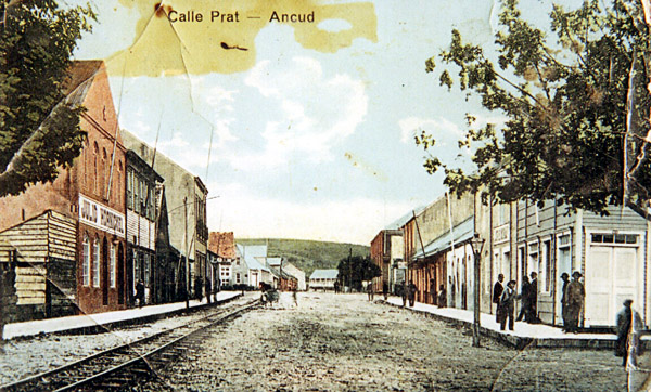
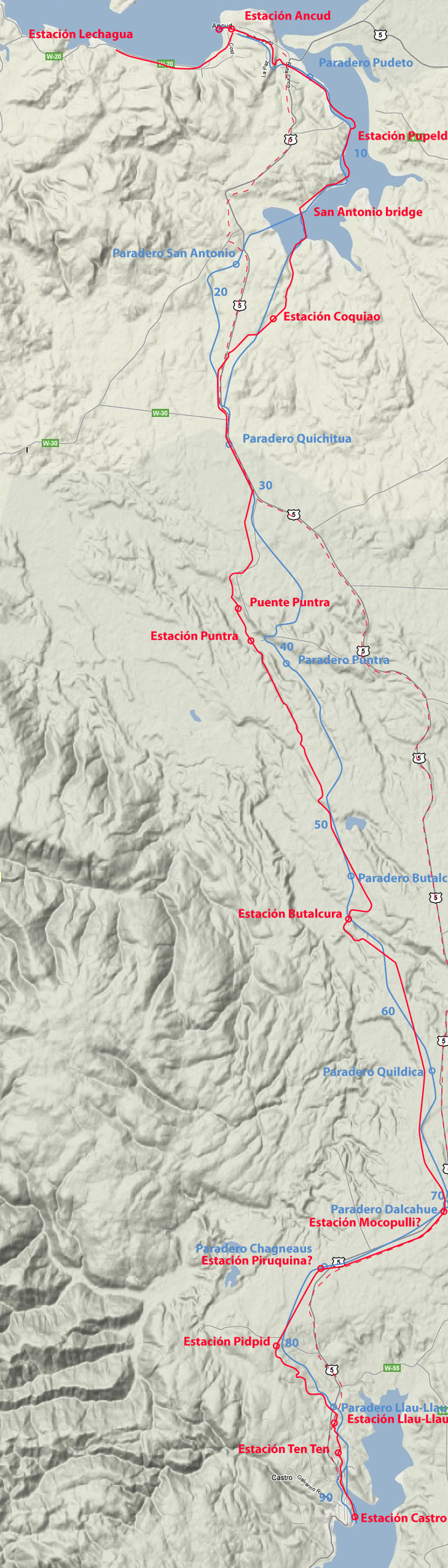
A view up Calle Prat in Ancud, shows the basic single track proud of the road surface. This is clearly from a tinted postcard but the date is unknown. Kindly provided by Señor Raúl Moroni from his collection. The route goes round the coast from Ancud for the first few miles, but then commences its traverse southwards across the middle of the island. Surveying for such a track was not helped by the number of westward flowing rivers in deep cut valleys. However, by climbing to the top of the central plateau or 'meseta' a reasonably favourable course could be followed from south of Butalcura down to Piruquina. A list of features along the route is in an appendix page. On the 8th September 1911 the construction teams working from Ancud and Castro met near Butalcura. Fitting out out continued until on 27th July 1912 the inaugural train ran. As well as the main Ancud - Castro line, a branch from Ancud along the coast west to Lechagua was built at the same time. This seems to have been mainly for the shipping of timber via Lechagua muelle, and in the hope that Lechagua might become a new large port. An exploratory map The blue line and names are those proposed by the Franco-Belgian syndicate appointed as consulting engineers to survey and design the whole route. As explained in paragraphs further down the page, there was a great deal of revision and redesign undertaken once construction had begun. The final route as constructed is displayed in red, and is clearly very different. The dashed red line shows the road from Ancud to Castro. This can be seen to follow closely the modern one on the underlying base map, sourced from Google Maps. It hould be noted that the coastline shown around the Pudeto river area is that now obtaining after the 1960 earthquake; that applicable during the life of the railway will have been somewhat different and with a rather narrower area of water.
Experience leads to a rethink Then came a section along the roadside which proved satisfactory and did not require any alteration. The drop down to Puntra, however, was completely redesigned, leading to the abandonment of the tunnel proposed by the Belgians. Many of these changes seem to have resulted from a rapid realisation that the climate and soil conditions in Chiloé demanded much more substantial engineering than those in the drier areas further north. In the various memorias produced for the Chilean congress there are clear signs that drainage, ballast, sleeper lengths, and wooden bridge piles had all been found inadequate, and that it was beginning to be realised that the wooden bridges themselves were rotting before the line had even been opened. There must also be a strong suspicion that sections of the trackbed on transverse slopes had been found to be unstable and that this led to the decision to re-survey long lengths. Beyond Puntra the route was also redesigned from scratch, the new alignment following a different tributary valley directly southward up onto the tablelands before dropping into the Butalcura valley. The new alignment then made a diversion west to gain another tributary valley which would enable it to climb again for its last and longest length up on the meseta. Part way along the high level stretch it rejoined the original planned route, which it then followed alongside the main road, past Mocopulli station, and then south-westwards through Piruquina to Pidpid. The line then drops steadily downhill towards Llao-Llao. This route was also redesigned, not resulting as elsewhere in a major re-alignment, but merely in a cheaper and more tortuous trackbed but one with fewer large earthworks. The impression received is that money was in short supply here, resulting in something of a switchback profile as the track approaches Castro. Certainly a little more investment might have resulted in a route which would have been easier for the small locomotives to work. Despite all these problems and the resulting changes, there is no evidence suggesting that the contractors were particularly at fault. Rather, it would appear that neither the DOP engineers, not the Belgian consultants, nor the contractors themselves, had the experience to realise that conditions in Chiloé were far more testing than those elsewhere in Chile.
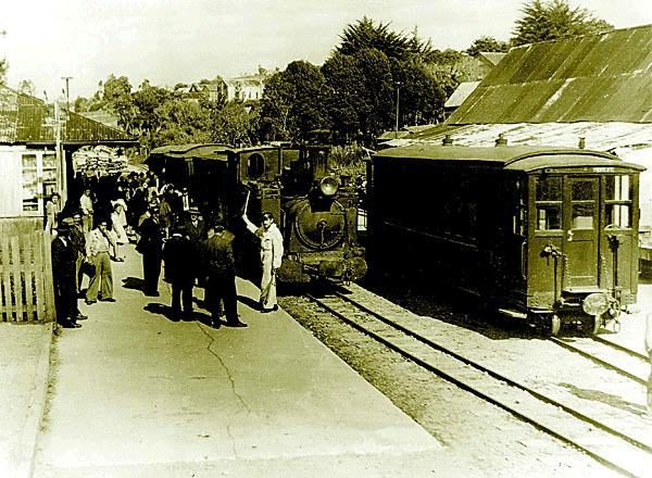
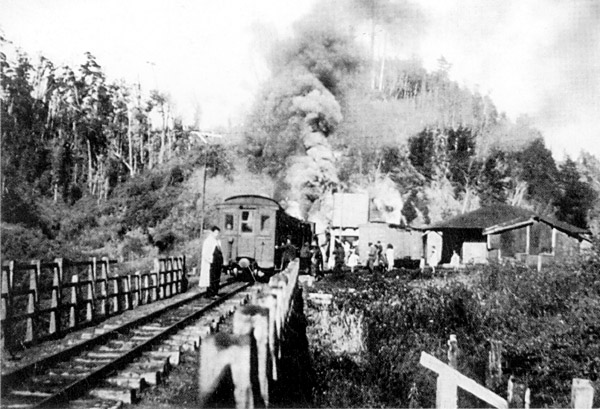
The photo above shows the departure of a train from Ancud station. Two coaches and a van seem to have been the usual passenger train formation. The photo is originally from the Gilverto Provoste collection (3), but this copy was forwarded by the Camahueto de Hierro student group from the Castro Archives. Whilst the route surveyed looks reasonable enough in the circumstances, the line eventually constructed shows signs of severe economies. The gradients are fairly steep. nominally at a maximum of 1 in 35 northwards to Llau Llau and southwards out of Butalcura. Even worse the three big bridges as initially constructed gave rise to serious concerns about safety. These were rebuilt in steel and concrete in 1925. Proposed extensions The photo below (2) shows two southbound trains at Butalcura. Judging by the clouds of smoke from the engine of the passenger train on the left, it is about set off up the steep grade to the meseta top, having overtaken the goods train standing in the loop. The ruins of the first wooden bridge over the río Putalcura are at the bottom right.
References:
15-12-11
|
|||||||||||||||||||

Chapter 6
The Chiloe Island 60cm gauge railway