 |
|||||||||||||
 |
|||||||||||||
 |
|||||||||||||
|
|||||||||||||
Main pages
Appendices
4 Pichi-Ropulli Osorno report •
9 Branchline station photos 2 •
11 Barros Jarpa Noel agreement ª
Chapter 5
The south end of the Chilean broad gauge


The 1960 earthquake
Lying as it does along an active tectonic plate boundary, Chile is subject to frequent earthquakes. These can be as big as those met anywhere, with shocks of magnitude 7.0 or greater occurring roughly annually within the country.
However, the quake which occurred on May 22nd 1960 was exceptional even by Chilean standards, and at magnitude 9.5 remains the greatest ever recorded on the surface of the globe. It was actually the strongest of a series of shocks that month, with three others exceeding magnitude 7.3. Whilst the epicentre that day was at Lumaco, on the Capitán Pastene 60 cm. gauge branch north-west of Temuco, the area of greatest devastation was around Valdivia. Several thousand persons were killed, not least by tsunamis of up to 25 m. height which battered the coast and by long-term changes in sea-level which flooded low-lying ground. Landslides also blocked the river outflow from Lago Riñihue, threatening the total destruction of the city of Valdivia if the dam had given way suddenly, an occurrence that was prevented by the huge engineering effort known as el Riñihuazo.
Such an event inevitably impacted seriously upon the rail network. At least 300 km. of route was closed by around sixty individual breaks, mostly landslips effecting embankments and cuttings, and damage to bridge abutments. Several of the most serious problems deserve individual attention.
Antilhue and Valdivia
At Antilhue, where the route north and south meets the line to Valdivia, not only was there severe earthquake damage to the flood relief bridge on the Río Calle-Calle floodplain, but also 200 m. of embankment nearby was washed away by the floodwaters coming down the river from Lago Riñihue in the days after the earthquake. A temporary alignment was constructed to enable trains to operate around the obstructions for several months. As in many other locations the most vulnerable parts of the bridge proved to be the poor quality mass concrete piers and abutments, whilst the steel spans survived well.
The route west down the river valley to Valdivia had been washed out in a number of places, including the bridge at Huaquilpo, and elsewhere had been covered knee-deep in silt. Valdivia station was not cleared of these deposits until August 1960, but in the meantime several hundred residents who had lost their homes set up camp in railway vans and coaches for a period of some weeks. As the photo below shows, the station itself had largely collapsed.
The mainline to Puerto Montt
The mainline south suffered two severe slips on steep hillsides at Los Lagos and Lipingue, the more northerly being around 800 m. long. The subsequent engineering debate focussed on means of draining the surface layers to minimise their tendency to flow under sudden stress.
Moving on southward, the central pier of the Río Maullín bridge at Llanquihue had tilted from the vertical and there was some debate as to whether the two steel tubes would still bear the weight of the spans and a train. Stress testing was to be undertaken, and reinforcement provided to fasten the spans more firmly to the pier. Modern views of the bridge suggest that considerable additional steelwork was added.
At Puerto Montt station it was necessary to demolish the station building, which in the longer term was replaced by a new structure, but more seriously the main wharf frontage constructed around 1909 had collapsed onto the seabed. It was suggested that this be replaced further east, involving the infill of a bay on the seaward side of the railway, but in fact the main port operations seem to have moved west to Angelmó. In the longer term this may have contributed to a transfer of traffic to road transport as this was some distance from the railway station.
The Panguipulli branch
This branch had only recently been extended by about 6 km., in order to bring the terminus down to the lakeside. The extension took the form of a hillside traverse out to the south-east, a semi-circular curve known as the vuelta de la guitarra, and then a second traverse across the lower part of the same hillside to reach the new station. The gravels of which the hillside was composed had seemed more than adequate to support the trackbed, but several thousand metres of the route slumped down the hillside under the earthquake stress. Whilst attempts were made to build up the levels using ballast, it is clear that visiting German consultants considered this to be very optimistic, and suggested that a cableway be constructed to bring the timber traffic up from the lakeside to the earlier high level station (1).
The closure of the southern end of the Puyehue branch
Whilst all of these problems were eventually solved, this was not the case at Entre Lagos. A reinforced concrete bridge near here could not easily be made safe, and thus the branch was immediately and permanently cut short to Chirre station.
Re-opening
It took several months for the damage to be rectified, and it was mid-September before passenger trains were again running to Puerto Montt, and the end of October before they reached Valdivia. No doubt replacement of the station buildings took several years.
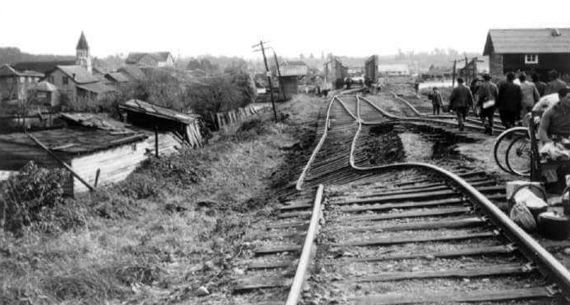
Slumping of embankments occurred at very many places. This example was at Puerto Varas.
References
1 Dipl.-Ing. Ernst Kockelkorn, 1960, Informe sobre los Resultados de las investigaciones hechas por la comisión de expertos alemanes enviada a Chile después del terremoto de 1960, available at http://www.biblioteca.uach.cl/biblioteca_virtual/libros/1961/551.220983CAN1961.pdf
9-3-2018