 |
|||||||||||||||
 |
|||||||||||||||
 |
|||||||||||||||
|
|||||||||||||||
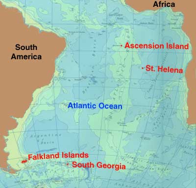
Further out into the Atlantic - a couple of rather smelly railways! There are four other islands in the South Atlantic, two of which have had railways. These two do stretch the geographical boundaries of this website more than a little, but I know of no other web pages considering these lines!
St. Helena and Ascension Island are both shown on the map above. The third and fourth islands - Tristan da Cunha, & the Brazilian island of Trinidad, do not seem to have had any railways and therefore are not shown on the map. A 'nightsoil' plateway...
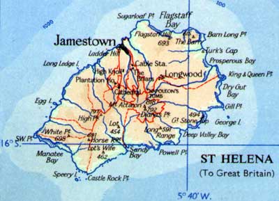
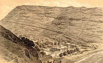
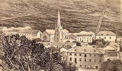
A famous feature of the town is Jacob's Ladder, a staircase of 699 steps leading to a fort high above. It was constructed in 1828-9 with plateway inclines (using flat plates with flanged edges for ordinary wagon wheels to run on) to a four foot gauge on either side of the steps (1). G. W. Melliss was the engineer, under the direction of the Honourable East India Company's Governor, Brigadier General Dallas (2). The precedents cited in late 1828 were similar inclines at Bridgenorth and Monmouth (13). Just four years later the island passed from 'John Company's' rule to the British Government. It appears that the plane was built privately though with government investment. In 1832 the plane was bought from its proprietors by the island government for £882 10s. The engraving below from 1863 shows Jamestown with the incline clearly visible up the cliff to the right (3). The illustration and others further down the page were found in the St. Helena Virtual Library and Archive maintained by Barry Weaver.
This was powered by donkeys or mules turning a drum at the top, and its main purpose was to lift 'nightsoil' or sewage up at night to be spread on the fields as a fertiliser. Stores were also taken up to the Ladder Hill fort, and farm produce lowered down into the town. Apparently the breakage of haulage chains led to 'unpleasant results below' and an emergency braking system was developed involving trailing spikes which would dig into the track in the event of a runaway. This was described and illustrated in detail in editions of the Mechanics' Magazine during 1832 and 1843. The relevant pages are available on an appendix page. The incline had been abandoned by the time that the ladder was reconstructed in 1875. More detail is given in an 1875 book (14) by J. C. Melliss, ex surveyor and engineer of the island, who was the son of G. W. Mellis, the incline's builder. The extract below summarises the incline's purposes, construction and eventual dereliction: The whole of the manure, which accumulates from stables, stockyards, &c., in the town, is thrown into the sea, instead of being conveyed up the hills, and returned to the land. By this long-continued practice the lands have become almost exhausted. Moreover, a large quantity of guano, collected around the coast, is exported to Europe, instead of being used in the Island, and it is much to be regretted that the Government permit it, merely for the sake of swelling the revenue by a paltry charge of 10s. per ton exportation fee. With such a system continually at work, is it surprising that the farmer obtains but a poor crop, and fruit trees blight and dwindle away ? rather is it a matter of astonishment that he obtains any return at all. Forty two years ago General Dallas, then Governor of the Island, was fully alive to this most ruinous system, and, with a view of supplying some practical means for lessening the cost of conveying the manure from the town up the hills, and back to the lands in the country, caused the erection of the ladder or inclined plane. This engineering work, carried out under the directions of Lieutenant G. W. Melliss, an artillery officer, comprised a ladder 900 feet in length, with upwards of 600 steps, communicating up the side of the hill from Jamestown to Ladder Hill, at an angle of 39' or 40', with a tramway on either side, upon which waggons, in connexion with ropes and machinery at the top, travelled up and down. By this means manure was conveyed up an almost perpendicular height of 600 feet and deposited, from whence it could easily be conveyed by the farmers. A secondary use of this "St. Helena Railroad" was to convey stores from the town to the garrison stationed in the Fort of Ladder Hill, and, as it would be most invaluable for both these purposes in the present day, it is very greatly to be regretted that the whole construction has fallen into disuse and bad repair, the woodwork being eaten by white ants. Indeed, it is said that these insects visited Ladder Hill through the medium of its longitudinal wooden sleepers. The second engraving is from a little closer, and was produced in 1857 (4). Again the incline is clearly visible.
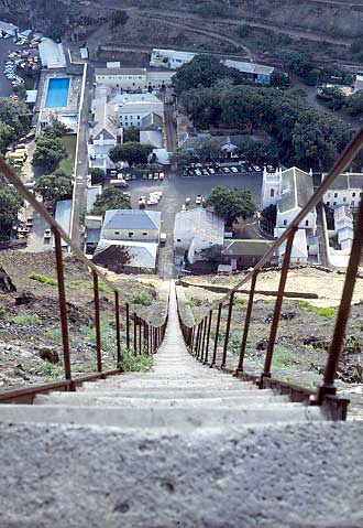
A modern picture by Barry Weaver looks down the ladder to Jamestown. Either side of the steps there is a sloping ramp of stone blocks. Whilst the whole edifice was reconstructed in 1875 these ramps may well have played a role as foundations for the plateway track.
Technical details of the arrangements, winch and runaway protection devices were published in the Mechanics Magazine in 1832 and 1834. Scans of these articles are available in an appendix page. More information about the Ladder Hill funicular plateway can also be found on the Funimag website. Coal and fresh water
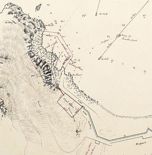
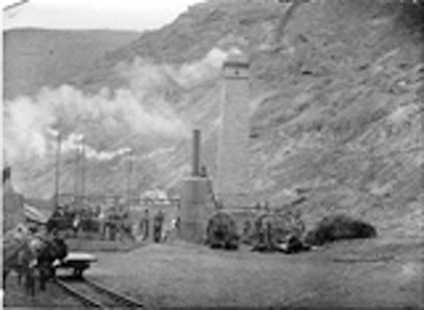
Somewhat later, in 1901, Rupert's Bay became the site of a sea-water desalination plant for the Boer War prisoner-of-war camps on the island. The plant was built, and tested, but was never used in earnest, though a large brick chimney survives. The map below shows the site of the desalination plant at the south end of the bay. A trolly (sic) line is shown, possibly of some length as it leads off the map at two points. The northerly line may well have brought in coal from the quay area mentioned above, whilst the southerly spur heads inland up the valley. The big chimney shown in the photograph further down the page is the small shaded square just south of the east-west rail line.
A very poor photograph of the plant being tested is displayed below. However it is worth publication as it clearly shows track and a four-wheeled wagon, possibly being hauled by a horse or mule though this is not certain. The gauge would appear to be 2' or close. The cameraman was facing east towards the main chimney, so the rail track is that shown running west to east in the map above.
...and guano lines!
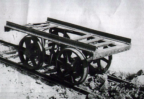
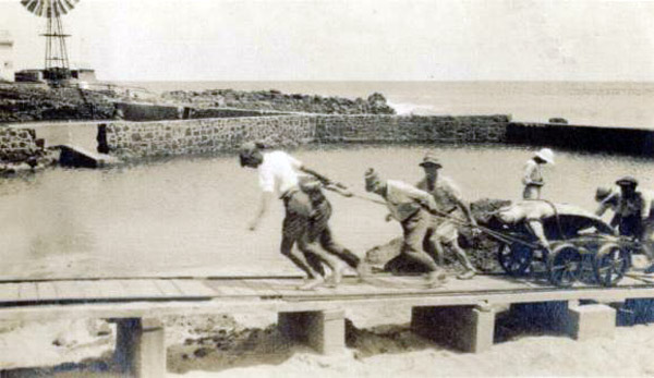
Initially there was a short 3 foot gauge line operating at least by 1863 to transport incoming supplies from Georgetown pier head to the main naval store, the coal store and the turtle ponds (5 , 6 & 7). Motive power was human. A wagon from this railway is preserved on the island, as shown in the photo below.
A huge turtle is hauled up to the ponds, to be kept alive until needed for food.
During the First World War a Marconi spark transmitter installation was built on the island east of Cross Hill. Messrs. (Holland, Hannen, and) Cubitts were the contractors just as on the Falklands. When the work was finished in 1915 there was correspondence about the disposal of the contractor's equipment (8). This apparently included four Foden steam lorries, and a light railway and trucks (but no mention of locos). The eventual conclusion was that one lorry would be retained on the island but the other three would be sent home. Nobody seemed to want the railway and it was to be offered to Marconi's if they could use it. Whilst no details were given it seems likely that it consisted of 'Jubilee' type track and four wheeled skip wagons. In 1923 a Mr. Sales formed the English Bay Company to extract guano (highly fertile deposits of bird dung) from a site of that name on the north side of the island. A camp grew up with a jetty, houses, barracks, stores and a hospital. There was a railway inland from the beach and apparently parts of the embankments can still be seen following the road from English Bay beach towards the power station. The route was on the left before the road joins the Power Station road, then following the current road alignment to the Klinker Club before curving off right through the BBC aerial field. Another separate section of track is supposed to have been laid at 'Ladies' Loo' near Porpoise Point. The company does not seem to have been a success, and by 1931 the site seems to have been dormant (9) Apart from the raised embankments there are sleepers and a wagon wheelset at 'Ladies' Loo' and the remains of 'an engine boiler' can apparently be seen at the beach car park. The rails seem to have been salvaged during the Second World War for other purposes and some still exist. It seems likely that the track and wagons came from the wireless station construction site, but no details of a locomotive have been discovered. Later, in the 1920s, guano was also exported from Boatswain Bird Island on the east coast. Jubilee track of 2 foot gauge was laid for the purpose (10). There was only hand power. This may have been by Charles Gleditz's Ascension Island Phosphate and Guano Co. Ltd. (11) or by the English Bay Co. mentioned above. The pier at Georgetown also had steam cranes until 1963. Three trolleys apparently survive on Ascension Island; one of them is still at 3' gauge, whilst the other two have been narrowed to 2'. There is also the chassis of a Ducroo & Brauns V-skip wagon (12). References: 19-8-11 |
|||||||||||||||
Main pages
Appendices
Chapter 11
Islands in the South Atlantic