Big whales, small engines!
The main clutch of whaling stations was in South Georgia, but the were other short-lived stations in the Falklands and further south. These are dealt with at the foot of the page, as are the known Pacific Ocean stations in Chile.
South Georgia
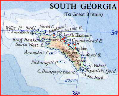
South Georgia lies about 800 miles ESE of the Falkland Islands, by which it has usually been administered. The main island is roughly 95 miles (150km.) from end to end. It is extremely mountainous with many glaciers and fjords, and has never been home to a self-supporting or indigenous population.
The map below shows the main features, and the settlements of Grytviken, Leith Harbour and Husvik are clearly marked. The red dots added to the map indicate the whaling stations. Note that they were all on the eastern, more sheltered, side of the island. From east to west they are: Ocean Harbour and then Godthul; Grytviken on its own in Cumberland East Bay; Husvik with Stromness and then Leith Harbour to its north; and finally Prince Olaf Harbour.
The old whaling stations
South Georgia's proximity to the antarctic whaling grounds meant that it grew to be the world's biggest centre of such activity, principally with Norwegian expertise. Eventually the whaling stations closed, killed by the development of the factory ship which could process the whales at sea, and then the decline in the whole industry. Whilst the island thrived there were seven main bases, at Grytviken, Godthul, Ocean Harbour, Leith Harbour, Husvik Harbour, Stromness and Prince Olav Harbour. Two others, at Allardyce (later Rosita) Harbour and Jason Harbour, were authorised but never built. There was also a small British administrative centre at King Edward Point near Grytviken. The stations opened and closed at different times as the industry waxed and waned. More detail of the history of the industry can be found at Paul Carroll's South Atlantic site (1), and particularly in the superbly comprehensive photographic coverage in Jim McLaren's South Georgia site (2). His 'Gallery 2' concentrates on the remains of the whaling stations.
Charts showing these whaling stations
Extracts fom old British Admiralty charts showing these whaling stations are presnted in a separate appendix page. Click here to bring the page up in a separate window.
Finding the whaling stations using Google Earth
Readers who have the Google Earth program can right click (control-click on a Mac) on the following link:
South Georgia whaling stations on Google Earth.zip
Save the file to your desktop and double-click to decompress it. Open the folder and drag the KMZ file onto Google Earth's Places palette. You will now find that you have placemarks for each of the whaling stations.
• Grytviken
• Husvik
• KingEdwardPoint These are static views of each of the stations as if from 500m up
• LeithHarbour
• OceanHarbour
• Stromness
|
Narrow gauge systems
I originally speculated that there might have been small 'Decauville' or 'Jubilee' type systems in the flensing yards of the South Georgia whaling stations. It turned out that in the 1980s Professor R. A. Smith had researched this topic and written an article in 'The Narrow Gauge' no. 97 (3) which quotes from 1950s reports of life in some of the seven South Georgia whaling bases. This was later reprinted in the Falkland Islands Journal. My researches have begun from his earlier findings. Professor Smith's full article is available on a separate appendix page.
It is clear that several of the stations used narrow gauge lines and that at least one used steam power. The lines were used to carry coal (needed for the saws and blubber boilers) and heavy items like harpoon heads and to provide safe transport across the permafrost which can turn into a quagmire in summer Jim MacLaren speculates that the lines fell increasingly into disuse when the stations moved over to oil as their main source of energy.
The systems are considered individually below, in east to west order.
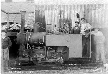
Ocean Harbour (formerly New Fortuna Bay) 1909-20
The site was operated by A/S Ocean of Larvik in Norway. It was a short-lived one, only lasting from 1909 to 1920. Most of the equipment was then transferred to Stromness.
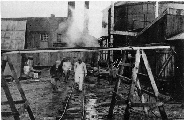
This is the only station definitely known to have used a locomotive. Robert Burton, who was curator of the museum at Grytviken suggests that this was because the shallow bay meant the jetty was further from the station itself. A photo of the steam loco in use has been unearthed by Mr. Burton (26). It shows it operating without a cab and with bracing struts to hold the chimney up. It may well have been built by Krauss.
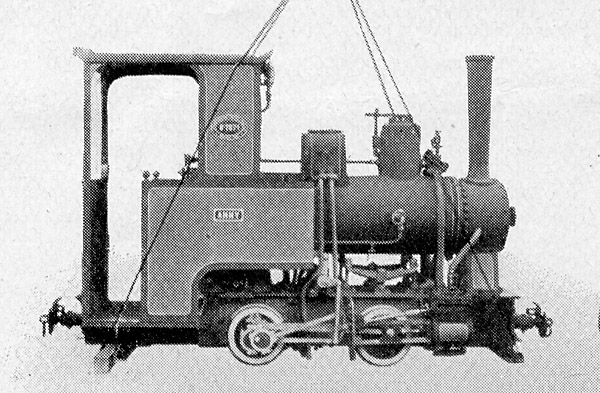
The picture below shows a similar light-weight Krauss as photographed by the builders.
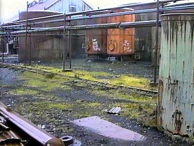
The photo below shows the derelict loco in 1982. (Photo by R. K. Headland kindly provided by R. A. Smith). Reports suggest that the loco has been lying overturned since at least 1926, and Mr. Burton believes that it may have been levered off the track to allow removal of the rails. The rail network here was rather smaller than at most other stations and it would be strange if this was the only location to have used locomotive power.
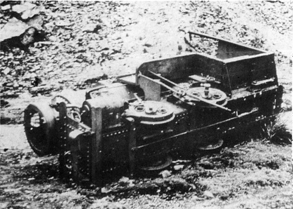
A number of photos taken in 1992 have recently been donated to the Narrow Gauge Railway Society. Some of these are reproduced below. The name of the original photographer is unknown.
Another view of the loco, from the cab end.
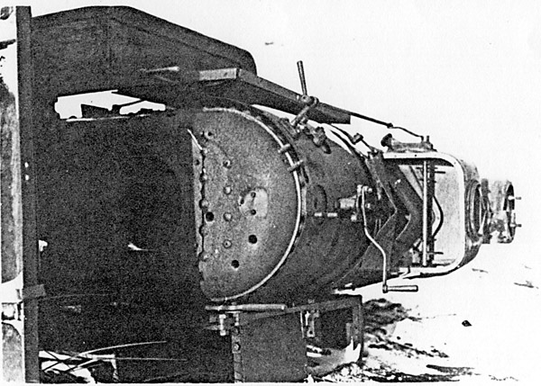
And from the smokebox end.
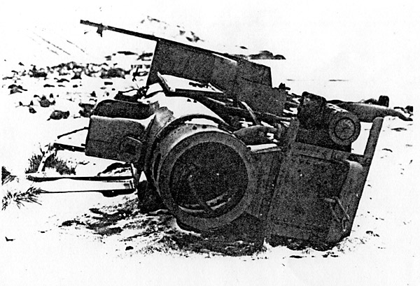
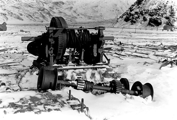
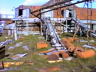
A single cylinder stationary steam engine.
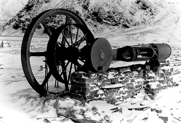
And, almost adjacent, a large winch.
Godthul 1908-29
This seems to have comprised a supply depot for a factory ship rather than a full-blown shore station. It does not appear to have had any railway tracks.
Grytviken 1904-71
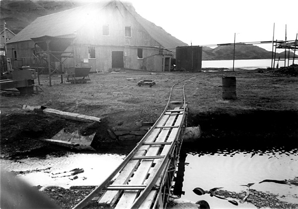
Grytviken was the longest-lived of the whaling stations, from 1904 until 1966. For a while it was operated by the Compania Argentina de Pesca, though whaling leases changed hands quite frequently. Nearby is the administrative settlement of King Edward Point (Cove). There certainly was railway track here, not just in the whale 'flensing pan' (cutting yard) but throughout the settlement. However, much of the track was removed during the 1950s. There are still some tracks and wagons present, under the bone loft for example (3A).
The narrow gauge tracks at Grytviken date from around 1912. As Ian Hart's history of the Cia. Argentina de Pesca makes clear, "For the handling and movement of stores, such as harpoons and coal, around the station, there were Decauville railways, the steel wagons being pushed by hand or hauled by winch." and " At the end of the cooking period, the residual solid matter from both the meat and bone boilers was shovelled out of the pressure boilers into manually operated trolleys on narrow gauge tracks. This was one of the most unpleasant jobs in the factory. The material was transported to the guano shed located behind the plan..." (4)
However, there were many changes over the years. In 1928 the capacity of the Gull Lake reservoir south east of the station was to be increased by building up the dam wall. In order to get the materials up to the dam site a narrow gauge line was built from the shore, " a considerable undertaking which was part constructed in snow." (5) Whilst some maps suggest that the line was only a few hundred yards long, a small photo in Hart's book (page 244) gives the impression that the railway followed a roller-coaster path up to the headwall at the back of a short valley, and that it must have been worked by a winch at the top.
At around the same date modifications within the station saw the construction of a wooden or steel viaduct right across the slipway at the front of the plan. The whales in fact had to be winch up through a single larger gap between the viaduct piers. As Hart explains (6), "It was a hazard which had to be negotiated when each whale was hauled up the slipway to receive its last rites. Sometimes a flipper or the spent harpoon sticking out of the back of the whale would foul the bridge, though it never actually brought it down." This structure seems to have disappeared in the late 1940s or early 1950s.
One further distinction held by the Grytviken railway system was that it was used to carry the coffin of Sir Ernest Shackleton on the way to its final resting place.
There is a museum at Grytviken which may well have more information or photos.
During 2004 a major environmental clean-up has taken place at Grytviken, with the aim of removing asbestos, leaking oil and other unfriendly substances. Whilst this could be justified on a number of grounds, there were serious concerns that it would harm the historic artefacts and atmosphere of the old whaling station. I am not aware that it has affected any remaining railway bits and pieces, but the programme has certainly had implications for other industrial remnants. In particular three of the remaining whale catchers have been refloated and then moved into an excavated basin. These include the Viola (later Dias) built as a steam trawler in 1906 in Hull, the Albatros built at Svelvik, Norway in 1921, and the Petrel built in Oslo in 1928 (22).
King Edward Point
This is the administrative centre where the island's magistrate lived, and from where the activities of the whaling companies were overseen. There was a rail track from the jetty at the end of the point eastwards for about 300 yards at least as far as the magistrate's house (later the police house). This was used to move baggage, fuel and supplies to the houses, rather for the whaling industry. It is this line which gets a mention in the late Nan Brown's Antarctic Housewife of 1951 (7) in which she has to transfer everything onto a wagon to get to the house.
Husvik 1907-61
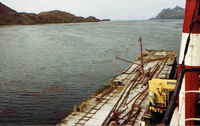
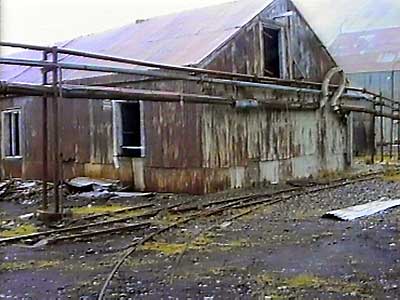
This also has track still in place. Another of Jim McLaren's photos, below, shows lines along the jetty, as seen from a vessel alongside. It was at this station that Professor Smith's informant, Robert Headland of the British Antarctic Survey, reported seeing something looking very like an engine shed. The station was operated by the Tonsberg Whaling Co., a Norwegian concern like many in the industry.
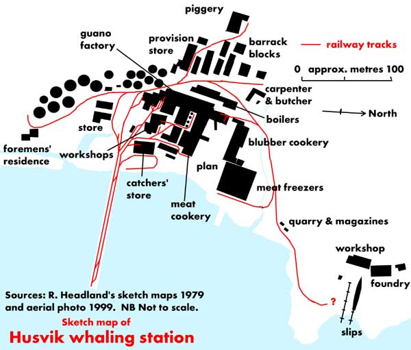
The sketch map above shows the extent of the railway system. The shed which might have been for a loco was near the slipways south east of the main site. The photo below was taken from a ship alongside the main pier.
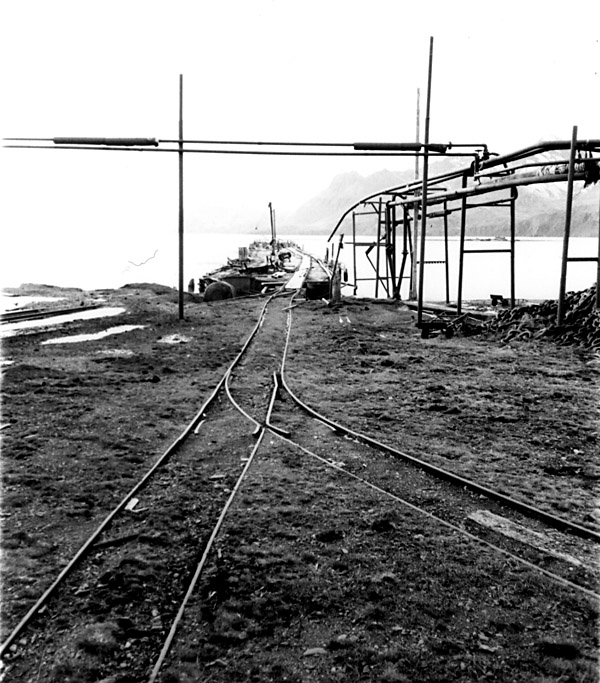
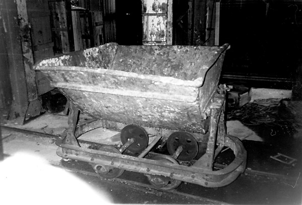
The 1992 photo collection passed to the NGRS, as mentioned above, also includes views of Husvik. Four of these are displayed below.
The main jetty illustrated above, is shown below from its landward end.
The line which goes off to the bottom right of the previous picture is shown here from further back. There is a skip wagon on the left.
The same skip wagon from the seaward side.
And another skip wagon, this time inside a building.
George Fremin's photos, below, were taken in 2002 (23).
The most southerly siding curves around the tank farm, with the foremens' house in the background.
Out on the jetty.
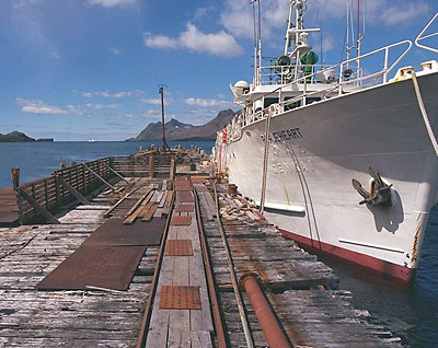
The seals don't seem too bothered by the railway tracks.
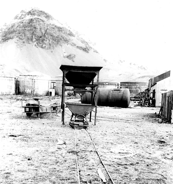
Stromness 1907-61
A view from the pier with an incomplete length of track in the foreground. This picture was taken by George Fremin (23).
The Sandefjord Whaling Co. had a floating factory ship here but there were also shore installations. Robert Headland records that the steam powered generator sets here originally came from the Bergen tramways system! (9)
A few more of Jim McLaren's photos are shown below.
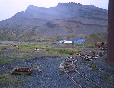
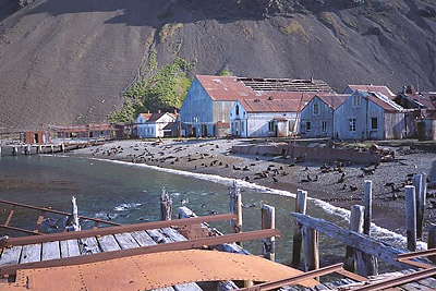
Leith Harbour 1909-66
This was another of the longer lived stations, closing only in the 1960s. It was operated by Christian Salvesen's of the other Leith – in Scotland. The photo immediately below was taken at the station in the 1950s (10). There is a wagon in the left background.
At this location the remains have survived at least in part.
The next photo, by Jim McLaren, shows tracks climbing steeply from the flensing pan up to the processing lofts. Amongst the drums in the right foreground is the frame of a 'Hudson' type skip wagon, whilst its tipping body is upside down in the centre of the picture.
Prince Olaf Harbour 1911-31
Whilst I have no photos of this location, some information was given in correspondence with the Colonial Office when the Southern Whaling and Sealing Company's lease ran out in 1935. Christian Salvesen and Co. were thinking of taking over the site and there was much discussion about the derelict equipment the previous tenants had left behind. Inventories listed 3000 feet or more of track some of which on a high level route had collapsed, a dozen or so sets of points and 32 tip wagons (11). There were also mentions of steam boilers and several (stationary) engines including one by Marshalls, but no hint of any locos!
The section of Admiralty chart no. 3835 (1931 edition) below, shows the layout of the station and the two sections of elevated railway mention in the 1935 inventories. Rails at ground level are not shown as they serve no useful purpose to shipmasters identifying their location.
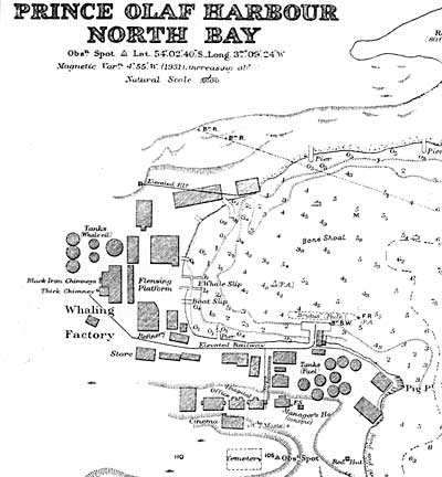
A 1988 photo showed that many buildings and several jetties still survive here. However the more southerly of the elevated railways did not appear to be still standing.
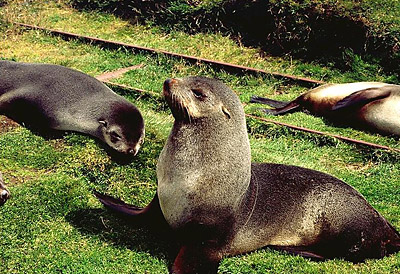
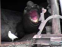 Photos of South Georgia's railways taken by enthusiasts are few and far between! Sometimes it is necessary to use shots taken for other purposes. Here, for example is a bull seal, probably not appreciating either the Sheathbill in the foreground or the skip chassis on the right! Photos of South Georgia's railways taken by enthusiasts are few and far between! Sometimes it is necessary to use shots taken for other purposes. Here, for example is a bull seal, probably not appreciating either the Sheathbill in the foreground or the skip chassis on the right!
Surviving relics
It might be thought that anything and everything would remain in such an isolated spot. However, the Grytviken tracks were clearly removed at some point. More seriously, it was the activities of an Argentinean scrapdealer in South Georgia that provided one of the sparks to the Falklands conflict in 1982. Señor Constantino Davidoff had negotiated to buy scrap with the agreement of Christian Salvesen and the British Government. The behaviour of the actual scrap removers at Leith Harbour led to protests and then the dispute escalated from there. Whilst I do not know precisely what was taken before the conflict blew up, Señor Davidoff certainly offered to sell salvaged narrow gauge track panels to preservation groups in Buenos Aires. The panels were apparently only 10ft (3m) long and very corroded (21).
Inevitably it is the weather which has taken the greatest toll. Buildings faced with corrugated iron are particularly vulnerable to high winds once a panel gets loose.
More recently there has been increasing interest in the remains of the whaling industry and some measures taken to conserve what survives. There is a small museum at Grytviken, with a single skip wagon amongst the relics outside.
Other whaling stations - in the Falklands, in Chile and around Antarctica
There were several other whaling stations in sub-Antarctic waters, though none of them lasted long. This is a topic where researches tend to spread beyond the immediate waters surrounding South America, at least partly because facts found by accident when looking at one area are unlikely to have been published anywhere else.
New Island, West Falkland
Christian Salvesen operated a whaling base at New Island off West Falkland from 1909 to 1915 (12). The equipment had been purchased from a station at Fasrudsfjord in Iceland. Photos suggest that there were at least two inclined railway tracks leading up from the shore; one, illustrated below, runs from the main jetty, whilst the other was alongside a slipway.
However, the catches from the waters around the Falklands were less good than those at South Georgia and much equipment was dismantled and taken to Leith Harbour after only a short life. Machine tools and a boiler were reported in 1988 to be still lying in situ, so there may still be relics of railway tracks or wagons.
Below: A tipping skip wagon can be seen in the distance whilst in the right foreground is a flat wagon with end panels but no sides. The sleepers would appear to have been made long enough for a double track., and indeed there appears to be a skip wagon on the left of the jetty, implying that a second line had been laid down there.
Deception Island, South Shetland Islands
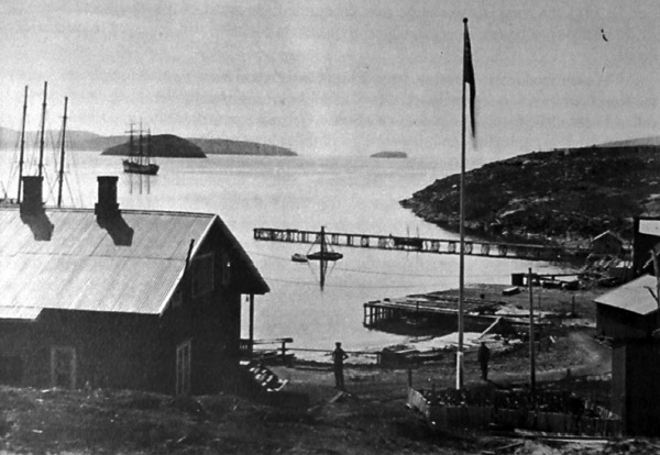
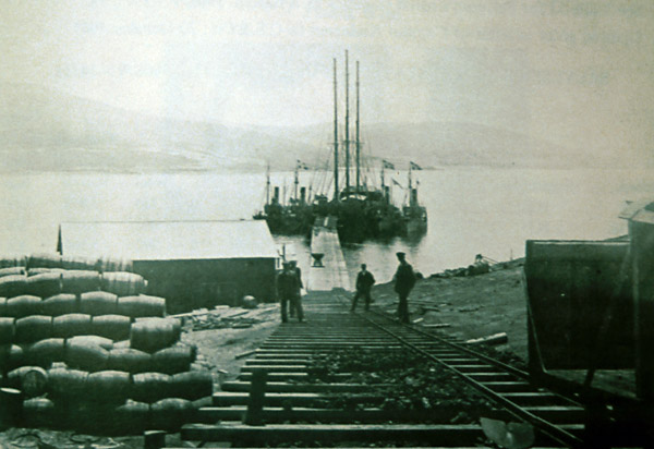
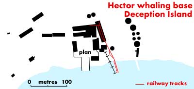
This is close to the Antarctic Peninsula. It had a whaling station known as the Hector station after its operator A/S Hector of Tonsberg, Norway. It was in operation from 1912 to 1931. Whilst the only photo so far seen of Deception Island in operation does not permit any railway lines to be distinguished (13), plans of the site show that there was a small hand-worked rail network (14). This ran from a double-tracked jetty directly inland with a halfway passing loop, to finish as sidings within a couple of buildings. A picture from 1926 in the care of the Scott Polar Research Institute apparently also shows inclined tracks leading up to the top of the blubber boilers.
Deception Island was later used as a BAS base but suffered severe damage from lahars (volcanic ash mud flows) during eruptions on the island in the late 1960s. Whilst there are remains of blubber boilers and the like (15), most buildings were demolished by the eruptions and the railway tracks were covered several feet deep in mud. However, Robert Headland reports that recent glacial melting has begun to wash away the ash and that by early 2003 the pair of points at the entrance to the erstwhile buildings had been uncovered.
Port Lockroy, South Shetland Islands
This was a safe anchorage rather than a full-shore station.
Establecimiento ballenero del Pacifico - Aisén, Chile
The online digital library of the University of Chile displays a single photo of the flensing plan ('faenadora de ballenas') at this location (16). The photo was reputedly taken during the 1920s, but nothing more is known about the operations there, or whether they used any rail transport.
San Pedro Sur, Chiloé, Chile
A whaling shore station was operated here by A/S Nor in 1909-10, and in 1911-12 by A/S Pacific. This may have been on the island of San Pedro south of Chiloe island proper. However, no details have so far come to light.
Punta Arenas, Magallanes, Chile
A shore station, 'landstasjon' in Norwegian, lasted longer here. The operator was Adolf Amandus Andresen from 1903-05, and then his company, the Soc. ballenero de Magallanes, from 1905-16. The station was in Bahía Aguila, and took an amazing 79 right whales in 1907 though the achievement was never repeated (24).
Signy, South Orkney Islands
This is another ex whaling station (operating 1920-26) which found a new use as a BAS survey station, however there had been few buildings ashore. The BAS laid a short section of track in 1963-4 from the whaling plan to the jetty to bring in large items like a pair of generator sets and modular building components. (17) (18). Track was later laid up the hill over snow to install the fuel tank behind the buildings.
Geoffrey Smith has recently reported that one survey station in these islands uses the round section rails used for tracking large film cameras and the like. Certainly there is a Uruguayan survey station on Southern Thule but no further details have appeared.
Port Jeanne d'Arc, Kerguelen
This whaling station was operated by A/S Kerguelen of Norway from 1908 to 1911 but results were disappointing. There was narrow gauge track on the jetty but further details have not yet come to light. Whilst one photo showed a single 60cm gauge track or similar along the jetty dividing into two at the seaward end, the base was fairly small and there may not have been a large network on land. There was another whaling station at Port Couvreux on the other side of the island. For more information see Paul Carroll's site as listed below. This includes links to Matthew Parris's reports' which mention the whaling stations.
Dumont d'Urville base
One source suggests that this French survey base on the Antarctic continent made the usual use of NG track to bring equipment ashore from a jetty (19). This would be the most southerly reported railway track by some margin.
Staten Island seal catching boat tramway
American sealers on Staten Island, at the extreme eastern tip of Tierra del Fuego, built a tramway to transport their boats across a narrow sandy isthmus dividing two bays. This was about a quarter of the way along from the eastern tip of the island, near Punta and Isla Año Nuevo. At this location a peninsula is only held together by a sandy spit a few hundred yards across. The tramway, of unknown gauge, enabled the sealers to move their boats quickly to either side of the isthmus as necessary when seals were sighted. J. R. Spears reported in 1895 that it had been constructed perhaps fifteen years previously (20). Motive power was presumably human.
Sealing station in Chubut
There was a sealing station on the Chubut coast north of Comodoro Rivadavia. It was disused by 1940 and a photo taken around that time suggests that all metalwork had been removed. Masonry bases, probably of trying boilers, remained but there was no sign of any rail tracks (25).
References:
1 Paul Carroll's South Atlantic website at <http://www.btinternet.com/~sa_sa/sasa.html>.
2 Jim McLaren's South Georgia website at <http://www.mclaren.gs>.
3 Article in The Narrow Gauge, No. 97. The magazine of the Narrow Gauge Railway Society.
3A Personal communication from Robert Burton, 2003.
4 Pesca - the history of the Compañia Argentina de Pesca SA, of Buenos Aires. 2001, Ian B. Hart, Aidan Ellis Publishing, UK. p173 & p245.
5 Ibid p244.
6 Ibid p245 & P276.
7 Antarctic Housewife.1951. Nan Brown. Publisher not yet discovered.
8
9 The Island of South Georgia. 1984. Robert Headland. Cambridge University Press.
10 Photo by courtesy of Prof. R. A. Smith
11 Colonial Office documents in the National Archives, Kew, London. Folder no. CO78/196/5.
12 Article in Falkland Islands Journal 1982.
13 Photo in Whaling in the Antarctic. 1931. A. G. Bennett. W. Blackwood, Edinburgh and London.
14 Sketch maps in Circumpolar Journal, Groningen, Netherlands, 1992, acknowledging a Royal Navy aerial photo as their main source.
15 Photos in a whaling display in Ushuaia Maritime Museum.
16 The 'Biblioteca digital' of the University of Chile contains a large number of old photos, though most of the railway related ones were taken up in the 'salitreras' of the Atacama. The photo mentioned above can be found by using this link to reach the site, going to the 'Fotografías' section and then moving on to the third page using the links at the foot of each page.
17 A concise account of Signy Base 'H'. 1988. Ed. by David Rootes. British Antarctic Survey, Cambridge, UK.
18 Personal communication from Robert Burton 2003.
19 A concise account of Signy Base 'H'. 1988. Ed. by David Rootes. British Antarctic Survey, Cambridge, UK.
20 The Gold Diggings of Cape Horn, p148. 1895. J. R. Spears. G. P. Puttnam’s Sons, New York and London.
21 Private communication from Jorge Garreta Mendoza 2004.
22 Article in Old Glory magazine, December 2004, p18-9.
23 Certain pictures of Husvik and Stromness were taken by George Fremin lll of amatuer radio station K5TR in Texas. His many photos of the South Atlantic are displayed on his website at <http://www.kkn.net/~k5tr/>.
24 Whaling in the Falkland Island Dependencies, 1904-1931, Ian Hart.
25 Photo discovered in Tierras Australes, Jerónimo Gómez Izquierdo, published by Empresa Editorial Bell, Buenos Aires,1942, page 71, and kindly forwarded by Señor Diego de Bunder of Puerto Madryn. The location of the establishment is reported as at S46º 06' 52" W67º 37' 43".
26 Photograph from the Christian Salvesen archive in the Edinburgh University LIbrary,.
16-2-10
|