Km
|
Location
|
Description
|
000
|
RIO GALLEGOS
(stations open in early 1990s are in capitals)
|
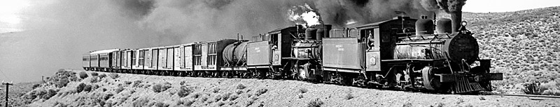
Coal port. Coal handling plant. Railway yard for the reception, unloading and formation of trains. Wagon tippler. Locomotive shed. Locomotive repair works. Railway management. Train Controller's office.(Empty and loaded trains ended and started their journey in this station before the new line was built to Punta Loyola. The main line runs south to north as far as Points No. 16 where it gives access to the engine shed and workshop area.)
|
002
|
Points No. 1
|
End of double track. (There is a triangle here for turning locos).
|
003
|
Level Crossings
|
National Route 3 (The main road south from Buenos Aires to Ushuaia), Radio station LU12.
|
???
|
PUNTA LOYOLA
|
New coal port for ships up to 25,000 tons.
Tippler.
Workshops.
Offices.
|
009
|
EMPALME KM 9 New junction
|
New line from Punta Loyola trails in on left.
|
017
|
DOMINGO LOPEZ
|
Crossing point for trains. Length of double track with spring points (ie points that can be trailed through, springing back to the normal running line afterwards).
The junction with the link to the new port of Punta Loyola is now east of here
|
035
|
Apartadero Km 36 Luis Piedra Buena
(old name was Palermo Aike)
On the right
|
Below, the estancia 'Palermo Aike' ('Estancia' is an Argentine term normally translated as 'cattle ranch'. However in this area it is best described as a 'sheep station' as used in Australia. Estancias in this part of the world tend to be quite large, 100, 000 acres being quite usual (a bit bigger than the Isle of Wight, to give a UK comparison). 'Aike' is a Tehuelche word (the original nomadic inhabitants of Patagonia) denoting something like 'place', 'location'. They had no concept of fixed villages or houses.
Three derelict 2-8-2s lay here at least until the 1970s, with some of the original ex-Pto Belgrano four-wheeled wagons.
|
036
|
Left hand curve
|
Radius of curve 170 m.
Start of incline.
|
052
|
'Apartadero' Km52
|
Crossing point for trains. ('Apartadero' literally something that separates, i.e.into a double track section.)
|
066
|
CAPITAN EYROA
(old name was Las Buitreras)
|
Station with passing loop, 'estacion de via libre'. (In Spanish it means literally a station with a free line. The term 'via libre'is the equivalent of 'line clear' in British usage. Here it means a station which authorises a train to enter a 'line clear' Encampment for track maintenance gangs.
|
069
|
On the right
|
'El Pedrero'.
Start of incline.
|
078
|
On the right
|
'Carateres'.
End of incline.
|
082
|
'Apartadero' Km82
|
Length of double track with sprung points.
|
---
|
On the right
|
Valley of the río Gallegos.
|
---
|
 |
Start of the incline "El Roble"
|
092
|
Bridge
|
Over 'El Roble' water. ('El Roble' = 'The Oak Tree')
|
094
|
Apartadero Km94
|
Crossing point for trains.
|
101
|
On the left
|
Estancia 'La Carlota'.
|
105
|
Bridge
|
Over the río Gallegos Chico. On right hotel. (The hotel owes its existence to the good game fishing in the area.)
|
107
|
GOBERNADOR MOYANO
(old name was Bella Vista)
|
Station with (two) passing loops (up to 1970s at least), 'estacion de via libre'. (By mid 1990s this was the only intermediate manned station.) Small village. Encampment for track maintenance gangs.(in addition there is a triangle for turning locomotives.)
|
108
|
On the left
|
Estancia 'Bella Vista'
|
109
|
On the right
|
A Suspension bridge dating from the start of the twentieth century.
|
123
|
T.A. Km123
|
On left. Water column with natural supply. ('T.A.' = 'Toma de Agua' = watering point. The point about identifying these facilities is that they are supplied naturally and are located to suit the presence of water. Water is, or was, available at all stations, but in these places it would be pumped by the ubiquitous windpumps which are such a feature of the landscape in Patagonia and in the Pampas.)
|
136
|
Apartadero INGENIERO CAPPA
(old name was La Sofia)
|
Station with passing loop, 'estacion de via libre'.
Water column. Change of engine crew.
Encampment for track maintenance gangs.
|
137
|
On the right
|
Suspension bridge dating from the start of the twentieth century.
|
147
|
T.A. Km147
|
On the left. Water column with natural supply.
|
160
|
Short incline
|
Start of the 'Pampa de El Zurdo' plateau. ('Pampa'= 'flat piece of land' or 'plain', from Quechua (the language of the Incas), 'El Zurdo'= 'The Left-Handed Man'.
Strong winds. Intense cold in winter down to minus 43deg.C. Forwards, are the Cordillera of the Andes.
|
161
|
Bridge
|
'El Zurdo' water.
|
167
|
Apartadero Comodoro Py
(old name was El Zurdo)
|
Length of double track with sprung points. Former station now abandoned (The Spanish term could also mean 'dismantled'. In most instances 'abandoned' is a better word as the facility has just been walked away from, and been pillaged from time to time.)
|
180
|
Gradient
|
End of the 'Pampa de El Zurdo' plateau.
|
181
|
Bridge (70 m span)
|
Río Gallegos. The biggest bridge on the line?
|
187
|
Apartadero Nicolas Kronlund Km187
(old name was Glen Cross station)
|
Crossing point for passing trains.
|
189
|
On the left
|
Estancia 'Glen Cross' (This is one of the very few names which is of English language origin. However, many estancias in the province were originally laid out by Scots settlers.
|
|
On the right
|
Start of the río Turbio valley. ('Turbio'=muddy)
|
199
|
On the right
|
Abandoned encampment for track maintenance gangs.
|
201
|
Desvio Gobernador Lista
|
Crossing point for passing trains.
Former station now abandoned.
|
204
|
Bridge
|
On the left 'Laguna Larga"'
On the right Estancia Laguna Larga
|
224
|
T.A. Km224
|
Water column with natural supply.
|
228
|
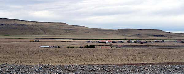
GOBERNADOR MAYER
(old name was El Turbio)
|
Station, normally not used for crossing trains. Small village called 'El Turbio Viejo'.
Abandoned encampment for track maintenance gangs.
|
234
|
Rospenteck
|
On the right. Military installation.
|
236
|
Level crossing
|
On the left. Road to the 'Paso Laurito' which leads to Puerto Natales in Chile.
|
240
|
Curves, left, right
|
Left hand curve of 150 m radius followed by right hand curve. Start of twisty alignment.
|
245
|
On the right
|
Old passing loop now disconnected. Former signal box Km 245 for holding and assisting trains. (The terminology suggests that this facility was used in association with a method of operation not now in vogue. Could it be that this was the foot of an incline against east-bound trains which needed banking assistance, perhaps in the days of the 2-8-2s?)
|
248
|
28 de Noviembre
|
On the left. Village.
|
251
|
Julia Dufour
(old name was La Dorotea)
|
On the left. Small village. Abandoned engine shed.
Siding and triangle. On the right ‘Hotel Capipe’.
|
253
|
Radio station
|
Look to your right. Radio mast for 'Radio Nacional'.
|
254
|
South points
|
Entrance to Rio Turbio yard.
On the left. Entrance to mine No. 5 and power station.
|
255
|
RIO TURBIO
(old name was Bacigalupo)
|
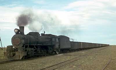
Terminal station. Shunting yard.
On the left. Entrance to mine No. 3
|
256
|
North Points
|
On the left. Coal washing plant.
|
257
|
Points No. 16
|
Above on the left. Rail access to Río Turbio engine
shed. Workshops for wagons and mining equipment (central saw mills, stores, railcar(?) workshops and others)
|
257
|
Points No. ?
|
On the left. Access to 'Via Raqueta' (= line in the shape of the head of a tennis racquet, ie. a turning loop.) and north entrance to the engine shed.
|
258
|
Estación Yacimiento
(Mine station)
|
The main line from Points No.? describes a curve of 180deg. and enters the Mine Station from the north and runs south on a ledge. Mine Station has been abandoned.
|
262
|
End of Line
|
Km 262 is the end of the main line and the start of the mineral lines serving mine No. 3 (?).
|